Esri CityEngine 2025.1.11669 โปรแกรมจำลองเมืองสามมิติ
ดาวน์โหลด โปรแกรม Esri CityEngine 2025.1.11669 (x64) โปรแกรมจำลองเมืองสามมิติ (3D City Modeling) ฟรี

ดาวน์โหลด Esri CityEngine 2025 ล่าสุด โปรแกรมจำลองเมืองสามมิติ
Esri CityEngine คือซอฟต์แวร์สำหรับการสร้างแบบจำลองเมืองสามมิติ (3D City Modeling) และการออกแบบเชิงผังเมือง (Urban Design) ที่พัฒนาโดย Esri ผู้นำด้านเทคโนโลยี GIS ระดับโลก โปรแกรมนี้โดดเด่นด้วยการสร้างเมือง อาคาร และโครงสร้างพื้นฐานขนาดใหญ่แบบ Procedural Modeling ซึ่งช่วยให้ผู้ใช้งานสามารถสร้างโมเดลเมืองที่ซับซ้อนได้อย่างรวดเร็วและแม่นยำ เหมาะสำหรับงานผังเมือง สถาปัตยกรรม ภูมิทัศน์ การวางแผนโครงสร้างพื้นฐาน การจำลองสภาพแวดล้อม และงานนำเสนอเชิงภาพในระดับเมือง
จุดเด่นของ Esri CityEngine คือภาษา CGA (Computer Generated Architecture) ที่ใช้กำหนดกฎการสร้างอาคาร ถนน และองค์ประกอบเมืองแบบอัตโนมัติ ผู้ใช้สามารถปรับพารามิเตอร์ต่างๆ เพื่อทดลองรูปแบบการพัฒนาเมือง (What-if Scenario) ได้ทันที เช่น ความสูงอาคาร ความหนาแน่น การใช้ที่ดิน และรูปแบบสถาปัตยกรรม ทำให้ CityEngine เป็นเครื่องมือสำคัญสำหรับการวิเคราะห์เชิงผังเมือง การประเมินผลกระทบ และการสื่อสารแนวคิดกับผู้มีส่วนได้ส่วนเสียผ่านโมเดล 3D ที่เข้าใจง่าย
Esri CityEngine ทำงานร่วมกับระบบ GIS ของ Esri ได้อย่างสมบูรณ์ รองรับข้อมูลจาก ArcGIS และสามารถนำเข้า-ส่งออกไฟล์ไปยังซอฟต์แวร์ 3D และเกมเอนจินยอดนิยม เช่น Unreal Engine และ Unity เพื่อใช้ในการเรนเดอร์ งาน Visualization และการจำลองแบบเรียลไทม์ เหมาะสำหรับสถาปนิก นักผังเมือง นักพัฒนาอสังหาริมทรัพย์ นักวิจัย และหน่วยงานภาครัฐที่ต้องการเครื่องมือสร้างและวิเคราะห์เมืองสามมิติอย่างมืออาชีพ หากคุณกำลังมองหา “โปรแกรมสร้างเมือง 3D”, “ซอฟต์แวร์ผังเมือง”, “3D City Modeling”, หรือ “เครื่องมือออกแบบเมืองด้วย GIS” Esri CityEngine คือหนึ่งในตัวเลือกชั้นนำที่ตอบโจทย์งานระดับเมืองได้อย่างครบถ้วน
คุณสมบัติเด่น (Key Features)
Core Features
-
Procedural Modeling: This is the most critical feature. Instead of modeling each building individually, CityEngine uses a unique programming language called CGA (Computer Generated Architecture) Shape Grammar to define a set of rules. These rules are applied to 2D footprint data (like building parcels or street networks) to automatically generate highly detailed 3D models of buildings, streets, and urban environments at massive scale.
-
GIS Data Integration: CityEngine is deeply integrated with the Esri ArcGIS ecosystem. It can directly import real-world geographic information system (GIS) data, such as:
-
Building footprints, parcels, and street networks (from shapefiles, geodatabases, OpenStreetMap, etc.).
-
Basemap imagery and 3D terrain data via the “Get Map Data” function.
-
This allows you to create 3D models based on real-world context.
-
-
Scenario-Based Planning & Visualization: It enables users to quickly create and compare multiple design alternatives or planning proposals (scenarios) by simply adjusting parameters in the CGA rules.
-
Dynamic City Layouts: Tools for generating and interactively editing street networks, where entire blocks and adjacent geometries automatically update in real-time.
Analysis and Reporting
-
Rule-Based Reporting: Users can script and generate real-time reports based on the procedural rules. This allows for instant calculation of metrics important for urban planning, such as Gross Floor Area (GFA), Floor Area Ratio (FAR), and building density for different design scenarios.
-
Customizable Dashboards: Create scenario-aware dashboards to visually compare the performance and metrics of multiple design alternatives side-by-side.
-
3D Zoning Visualization: Easily create and visualize 3D representations of zoning regulations and land-use conditions to inform your designs.
Interoperability and Workflow
-
Integration with ArcGIS Urban: Seamlessly integrate city models and scenarios with Esri’s platform for planning and managing urban developments.
-
Industry-Standard Export: CityEngine supports exporting your finished 3D city models to a variety of industry-standard formats, including:
-
FBX, OBJ, USD, Alembic, Collada for use in game engines (like Unity, Unreal Engine), high-end visualization software, and movie production.
-
Scene Layer Packages (SLPK) for sharing 3D scenes on the web via ArcGIS Online and ArcGIS Enterprise.
-
-
Python Scripting: For advanced users, a Python scripting interface is available to automate workflows and repetitive tasks.
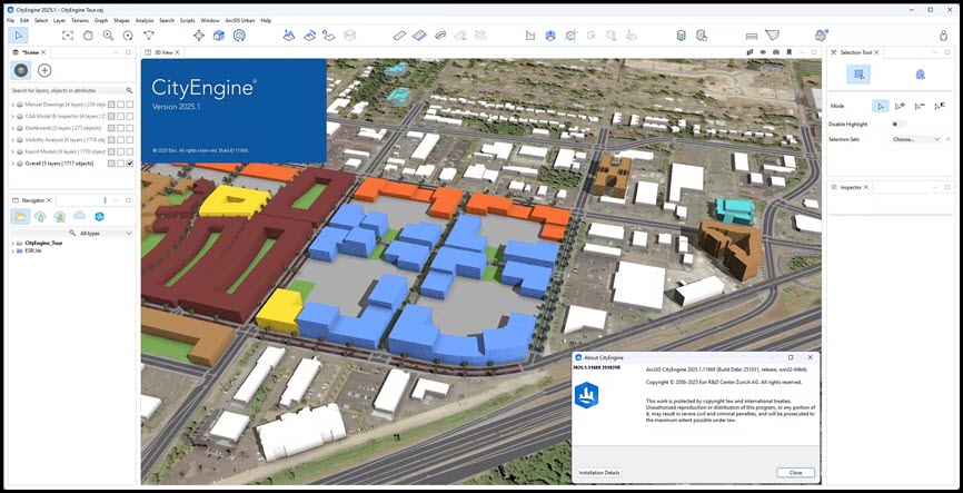
ภาพตัวอย่างโปรแกรม (Screenshots)
ความต้องการของระบบ (System Requirements)
CPU:2 GHz dual-core CPU minimum (at least Core2 Duo compatible Intel/AMD)
Memory:16 GB
Space:2 GB or more
GPU:Nvidia—GeForce 600 and later / Quadro 600 and later / AMD—Radeon HD 7000 and later
ข้อมูลไฟล์ (File Info)
License : Trial
Software Version : 2025.1.11669
ชื่อไฟล์ : ECE2025.1.11669(64).rar
ขนาดไฟล์ : 1.21 GB
นามสกุลไฟล์ : *.rar
เซิฟเวอร์ : Pixeldrain | MediaFire
วันที่อัพโหลด : 14/12/2025
แก้ไขล่าสุด : 14/12/2025
รหัสผ่าน : sbz
โปรดระวังโฆษณาเด้งไปหน้าอื่น เช็คชื่อไฟล์, ขนาดไฟล์ ก่อนดาวน์โหลดทุกครั้ง
ดาวน์โหลด
รหัสแตกไฟล์คือ sbz
วิธีดาวน์โหลด วิธีแก้ลิ้งค์เกินโควต้า
" This file is for trial/educational and non-commercial use only. Using non-genuine software may cause various problems to use this software without any problems Please purchase a genuine license from the official website. "